
|
|
Sustainability
by Design: |
||||
| goals | partners | news | links | ||
edge
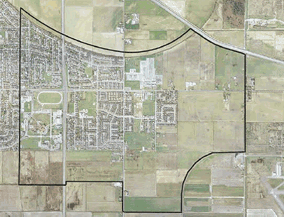
STUDY AREA: EAST LADNER, DELTA
 GOOD & PLENTIFUL jobs
CLOSE TO HOME
GOOD & PLENTIFUL jobs
CLOSE TO HOME
DIFFERENT
housing TYPES
MIXED
USE corridors ACCESSIBLE TO ALL
FIVE
MINUTE walking DISTANCE
ACCESS
TO natural AREAS AND PARKS
LIGHTER,
GREENER, CHEAPER, SMARTER
infrastructure
CASE
STUDIES
Edge:
East Ladner, Delta
The East Ladner Edge charrette is a collaborative
planning and design exercise for illustrating a 50-year vision of how
sustainability principles and designs could be realized in the East Ladner
study area, with a specific focus on the design of the agricultural-urban
edge.
>> EAST LADNER EDGE CHARRETTE
DESIGN BRIEF
[DOWNLOAD]
edge:
existing conditions
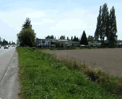
East Ladner is located on the eastern portion of the larger Lander community,
bisected by Hwy 17 and Hwy 10. The area is situated on alluvial soils
on the Fraser River floodplain, and drains via pumps, dikes, and floodgates.
The community is surrounded by rich farmland and ALR, with a desire for
healthy rural / residential interfaces.
edge:
50 year VISION
Facilitate and implement a vision of a
complete and sustainable East Ladner community which
will:
• Have a vibrant Civic Centre District;
• Integrate, capitalize on, and add value to the edges of selected
urban land uses with agricultural and natural areas where appropriate,
while respecting their unique needs and functions;
• Support compact communities through infill and strategic edge
development to resist
developing into surrounding agricultural lands.
• House 1900 new residents by 2050;
• Support between 1620 and 1650 new jobs by 2050;
| GOOD
& PLENTIFUL jobs |
|
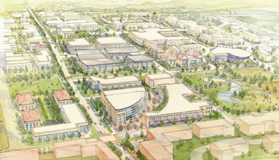
| 1. |
Civic
Centre Revitalization: • Capitalize on wasted space • Community Heart • 1620-1650 new jobs (approx. double) |
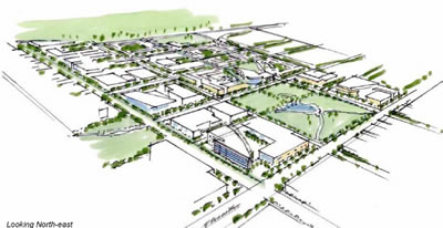
| 2. | Civic
Centre as a social and cultural hub: • New Civic uses: Theatre, Museum, open space • Gateway to Community, transit exchange: Looking North-east |
3. |
Employment
diversity: • Commercial, institutional • Extended hospital & care facilities • Mixed-use corridors along main streets • Home-based businesses, above- garage spaces • Small retail “farm market” opportunities |
| DIFFERENT housing TYPES |
|
| 1. |
Civic
Centre Housing Opportunities: • Mixed-use apartments (200 uph); 870 new units • Ground-oriented rowhouses and medium-density residential (90-100 uph); 1250 new units |
| 2. | Redevelopment
Opportunities: • 340 new units throughout single family areas. • Townhouse units • Subdivision with coach houses and rear-lane access. |
| MIXED
USE corridors ACCESSIBLE TO ALL |
|
| 1. |
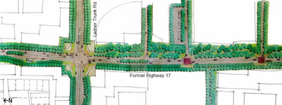
Highway
17 and Ladner Trunk Road transformed: • Locally-serving, 4 lane route • Vibrant Gateway intersection, connectivity • Jobs, housing, transit stops along Route 17 and Ladner Trunk Road |
| 2. | Connectivity
throughout: • Preserved key farming corridors • Safe, multimodal, accessible paths with at-grade crossings over Route 17 connects previously divided community |
| FIVE
MINUTE walking DISTANCE |
|
| 1. |
Integrated
multi-modal network: • Pathways, greenway boulevard and trail network |
| 2. | Street
interconnectivity: • Cul-de-sacs transformed into walkable grid; neighbourhoods reconnected |
| ACCESS
TO natural AREAS AND PARKS |
|
| 1. |
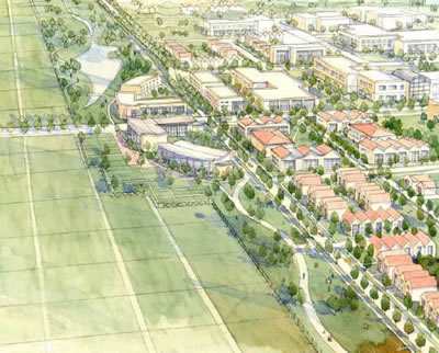
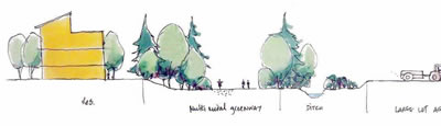
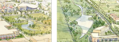
Edge
Paradigm 1: • Fine-grain, low-intensity agricultural parcels interface with adjacent front-facing residences |
| 2. | Edge
Paradigm 2: • Vegetated greenways with multi-modal pathways along large agricultural lots |
3. |
Edge
Paradigm 3: • Development within a 300-metre wide urban edge-management zone funds compatible uses with the abutting 300-metre agricultural edgemanagement zone |
| 4. |
Edge
paradigm 4: |
| LIGHTER,
GREENER, CHEAPER, SMARTER infrastructure |
|
| 1. |
Street
Systems: • Narrowed roads and connected street grid with greenway and street trees. |
| 2. | Energy
Efficiency: • District heating system for Civic Centre. |
3. |
.Green
Systems: • Park and wetland within Civic Centre • Connected ditches maintained throughout |